- News
- Reviews
- Bikes
- Components
- Bar tape & grips
- Bottom brackets
- Brake & gear cables
- Brake & STI levers
- Brake pads & spares
- Brakes
- Cassettes & freewheels
- Chains
- Chainsets & chainrings
- Derailleurs - front
- Derailleurs - rear
- Forks
- Gear levers & shifters
- Groupsets
- Handlebars & extensions
- Headsets
- Hubs
- Inner tubes
- Pedals
- Quick releases & skewers
- Saddles
- Seatposts
- Stems
- Wheels
- Tyres
- Tubeless valves
- Accessories
- Accessories - misc
- Computer mounts
- Bags
- Bar ends
- Bike bags & cases
- Bottle cages
- Bottles
- Cameras
- Car racks
- Child seats
- Computers
- Glasses
- GPS units
- Helmets
- Lights - front
- Lights - rear
- Lights - sets
- Locks
- Mirrors
- Mudguards
- Racks
- Pumps & CO2 inflators
- Puncture kits
- Reflectives
- Smart watches
- Stands and racks
- Trailers
- Clothing
- Health, fitness and nutrition
- Tools and workshop
- Miscellaneous
- Buyers Guides
- Features
- Forum
- Recommends
- Podcast
news
 The 'Ravine' Swansea Council
Cycle route in Swansea or Alpe d'Huez? Hairpin-packed active travel path opens
Alpe d'Huez, Sa Calobra, Stelvio Pass, Lacets de Montvernier... is this new cycle route in Swansea the latest addition to the great hairpin-covered climbs of the cycling world?
At 1.4km long, probably not. But it makes a pleasant change from the usual fare of painted cycle lanes and baffling designs full of active travel obstacles.
> How fast!? We take a look at Tom Pidcock's Alpe d'Huez-conquering Strava file
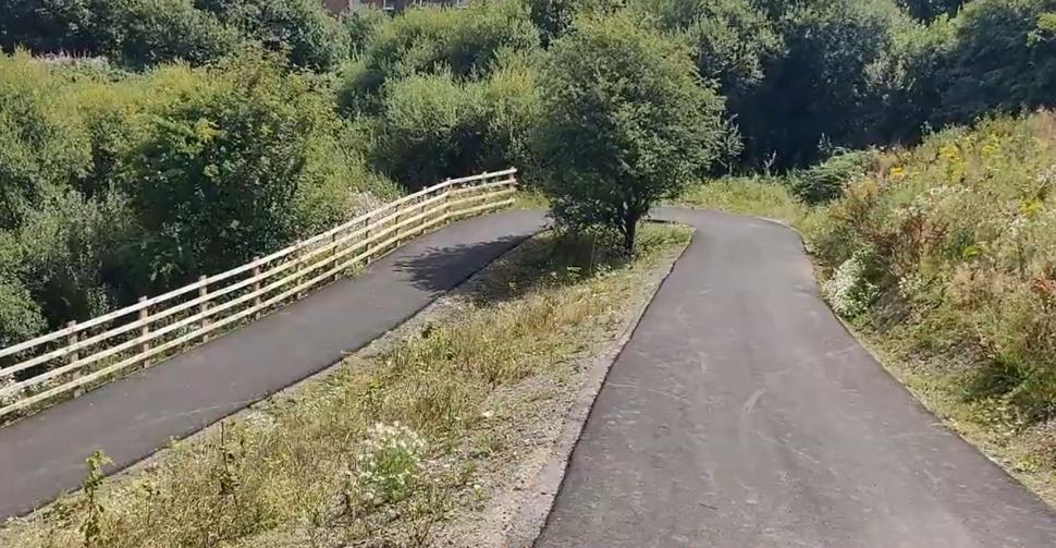
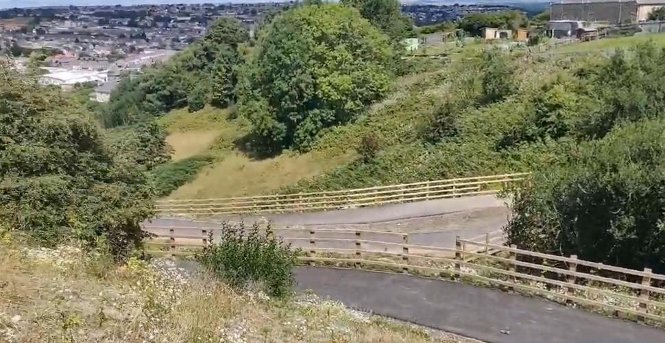
Swansea Council has turned the Ravine, a site in Townhill previously blighted by fly-tipping, into a shared-use path for walkers and cyclists which zig zags up one of the city's hillsides, transforming it into a miniature replica of some of Europe's great climbs...
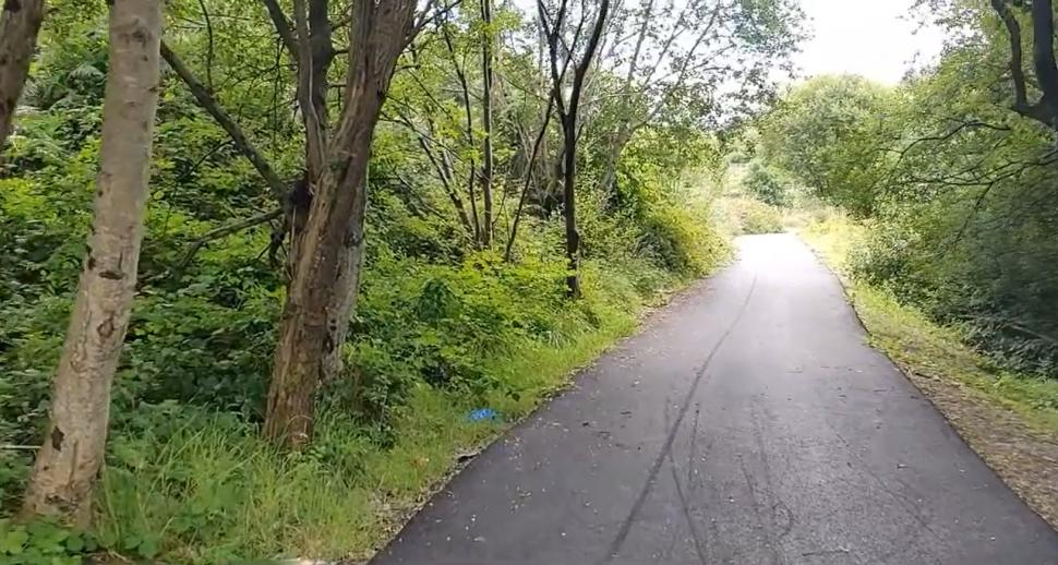
The route is lined with trees and greenery, and offers a route between Gwent Road and Gors Avenue that avoids the traffic, as long as you're willing to tackle the numerous switchbacks.
Andrew Stevens, Cabinet Member for Environment & Infrastructure, told Wales 24/7: "This route is one of the more challenging that we have created. Our aim was to link up two sections of the community that are at very different levels in height.
"It's a steep location and so we have created a zig zag-style path which can now be used by everyone.
> Raleigh Chopper vs Alpe d'Huez (+ videos)
"In years gone by, the Ravine has been a hot spot for fly-tipping. Hopefully, now we have opened it up and reclaimed the site, we will see less of this type of behaviour."
The route was funded through to the Welsh Government's Active Travel initiative, with more local routes to come following a successful bid for more than £7 million to support walking and cycling infrastructure projects.
Cllr Andrew Stevens celebrated the news: "Once again, Swansea has been successful in securing important funding that we want to invest in our transport network in the city.
"We have been working extremely hard for a number of years, creating new walking and cycling routes that give residents and visitors alternative ways to get around without needing to use a car.
"In the long term, our aim is to have a fully linked-up network of walking and cycling routes across Swansea so that every community benefits from more sustainable methods of getting around."
Dan is the road.cc news editor and joined in 2020 having previously written about nearly every other sport under the sun for the Express, and the weird and wonderful world of non-league football for The Non-League Paper. Dan has been at road.cc for four years and mainly writes news and tech articles as well as the occasional feature. He has hopefully kept you entertained on the live blog too.
Never fast enough to take things on the bike too seriously, when he's not working you'll find him exploring the south of England by two wheels at a leisurely weekend pace, or enjoying his favourite Scottish roads when visiting family. Sometimes he'll even load up the bags and ride up the whole way, he's a bit strange like that.
Latest Comments
- hawkinspeter 8 min 23 sec ago
You need to try a different shop - my Bonts were sold as a pair
- levestane 9 min 45 sec ago
This is tech doing it's job, extracting money from punters.
- imajez 11 min 50 sec ago
I never pay attention to Facebook suggestions/ads, but the very beautiful and clever split frame design in a Feather Cyles post caught my eye. It...
- belugabob 21 min 36 sec ago
Or we could adopt the Japanese approach.....
- chrisonabike 36 min 30 sec ago
Agreed, but in the UK we have policing which to a greater or lesser extent relies on assistance from members of the public. So part of that...
- SecretSam 50 min 40 sec ago
Maybe take some drugs to calm your nerves...
- SecretSam 51 min 33 sec ago
So...don't cycle on it. Lots of other routes around that area. Source: I used to work there.
- Hirsute 56 min 18 sec ago
Armando Iannucci "Today is Day One of humanity’s Idiolithic Era."
- Steve K 1 hour 11 min ago
My photochromic specs have just turned up in the post today
- Paul J 1 hour 18 min ago
Downhill Alpe d'Huez TT would be _awesome_. And someone should organise one for real!...


Add new comment
17 comments
If you're looking for goverment funding you'll have to meet the design guidance, if you meet the design guidance you'll not have a gradient over 5%, so it's usable for all. If the gradient is 5% then the length is minimum 20x the height difference - if you have to go up a 25m hill then the length of path has to be 500m minium. If it doesn't fit to use that 500m length as part of the A to B, or if the land constrains things, or if that would make for more level difference, then you zigzag.
The hairpin radii look tighter than ideal, but of course if you make them more sweeping you'll get more speed complaints. If you want to avoid that potential issue by segregating pedestrians and wheeled users then you'll be building 2 of those zigzag 500m long paths in parallel, or some really comment-worth Escher layout combination ;-).
It's just how the 3d geometry works in practice - as more things get built to a more usable standard expect to see a lot more of this sort of thing.
I wonder how long it will be before a concerned local citizen says they need to put speed bumps and 'slow down' signs on it...
Some A frames and a "kissing" gate...
I'd fund travel expenses* if that happened and a disabled road.cc member felt like visiting and then making a legal challenge.
* mainland UK only, I better qualify...
Cyclist see a challenge, Pedestrians see a dogpark and latrine.
Full marks to Swansea for getting more than £7M from the Welsh Government's Active Travel fund for this project and others in the area.
Cardiff Council have applied for and recieved £6.3M for continuing stage one of the Cardiff Cycle Superhighways scheme from the same fund.
Caerphilly Council (where I live) however have not appled for a single penny of this 'free' money to construct new or improve active travel facilities even though there is a pot of money of around £50M held by the Welsh Govt. waiting to be applied for and that amount is for this year alone.
You will not get a straight answer from anyone in Caerphilly Council why they do not want the money, I assume it is just too much like hard work for them and all they plan for is car usage.
I'd love to see them link the end of the taff trail at the top of Nantgarw hill to the cycle paths running up to Hendre school and St Cenydds.
Would properly join up the network and would be easy to do.
Yes I agree, that would be great and Caerphilly Council can't use the excuse that they do not have the money to do it.
If you live in this area it is obvious that they do not want to do it.
They need someone new with vision and drive not employees stuck in the past with no interest apart from getting a monthly pay check.
South /Mid Wales appears 'far ahead' of England in regards to cycling/walking routes.
That road links one very deprived area to another, off-road. The additional infrastructure is good and probably needed!
Anecdotally, 20 years ago when I lived there, that specific area was certainly not the sort of place you'd ride around on a pricey bike.
And has done for at least a decade.
Yeah - very noticeable when friends and I cycled the Lon Las Cymru in May. We were on segregated cycle lanes for almost all of the first day - about 80km from Cardiff - and most of the second and third days were segregated or basically traffic-free farm roads. A few more 'proper' roads after that but also many more glorious cycle paths. The run into Caernarfon was an especial joy. Apart from the gates every time it crossed a road.
While North Wales are the exact opposite, they love their A Frames.
That looks interesting. I'm sure the local cycle clubs will want to have it closed off from time to time for ascents and descents.
Unfortunately a lot of people are going to cut those corners when descending, unless some sort of barrier is installed.
Thats probably what you want though. Idiots will go around the outside and will only have themselves to blame when they get in trouble.
Buffalo girls?
Apparently Lance Armstrong consulted on the design.